June 2019
Six national parks, three members of the family, and a camera that received a very thorough workout. That was our June 2019 vacation through the Southwest with bapierson and LEGOexplorer.
The photograph at the Capitol Reef entrance sign says quite a bit about the trip. We had magnificent scenery all around us, and we still found time to be a little ridiculous for a family picture. I am glad we did.

Our route took us through Zion, Bryce Canyon, Capitol Reef, Arches and Canyonlands in Utah, then into Colorado for Mesa Verde. Geocaching ran through those days, giving us things to notice along the way. With EarthCaches and Virtuals, the place itself was often the reason for the stop.
Zion: Looking Up, Then Climbing Up
We began our park visits in Zion on June 10. The canyon walls made an immediate impression. Stand down near the river and the sandstone seems to go on climbing long after your neck has decided it has done enough.

The Virgin River has helped carve this canyon through layers of rock, including the great walls of Navajo Sandstone. EarthCaches such as Zion Narrows (GCZ5YD) encouraged a closer look at the landscape.
In fact, of all the things I was looking forward to during our visit to Zion National Park, hiking The Narrows was near the top of my list.
There's something about the idea of hiking through a narrow canyon, surrounded by towering sandstone walls with the Virgin River running beneath your feet, that makes it a pretty appealing adventure.
Unfortunately, Mother Nature had other plans.
One of my photographs from the visit pretty much sums up the situation. The sign couldn't have been any clearer:
“NARROWS CLOSED.”
High water had closed the route upstream. The Riverside Walk was still open, but the hike I'd been looking forward to was off the table.
It was disappointing. The Narrows wasn't just another trail I happened to notice on a park map. It was one of the experiences I'd been anticipating before we ever arrived.
The following day, LEGOexplorer and I climbed to Angel’s Landing (GCG2ZP). Doing that hike with my son became my highlight of the trip. The final chained ridge and the views from the top deserve a story of their own. For now, I will just say that the climb gave me plenty of opportunities to appreciate both the scenery and the need to catch my breath.
Which in hindsight was funny, Angels Landing, wasn't something I'd even considered as a family hike. It simply wasn't part of our plans. However, that's one of the realities of traveling to national parks. You can research the trails, plan your itinerary, and look forward to a particular experience for months, but nature still gets the final say.
Bryce Canyon: A Landscape Full of Hoodoos
On June 12, we moved on to Bryce Canyon. After Zion’s enormous walls, the crowded spires and fins of the Bryce amphitheater gave us a different way to look at the Southwest.
At Bryce Canyon National Park - Inspiration Point (GCHQMX), the view lived up to the name. My photograph from that evening spreads across the hoodoos toward distant plateaus. It is one of those scenes where a wide photograph starts to make sense, because choosing one little piece hardly seems fair.

The National Park Service explains how weathering and erosion shape the hoodoos, including water freezing in cracks and breaking rock apart. Learning a little about that process gives all those unusual shapes something more to them than a good photograph. Although I was certainly happy to take the photograph too.
Capitol Reef: A Bridge and a Family Portrait
Capitol Reef followed on June 13. The entrance sign supplied our family portrait, and Hickman Bridge - Capitol Reef NP (GC1D9K4) supplied another reason to get out and explore.
Our photographs from the trail include bapierson and LEGOexplorer taking a seat on a rock ledge, with sandstone rising around them. Those are the pictures I like having alongside the big scenic views. Years later, I can see who was there as well as what we came to see.

The park protects much of the Waterpocket Fold, a nearly 100-mile warp in the earth’s crust. That is a fairly substantial wrinkle. Between the folded layers, rock domes and natural bridge, there was plenty to occupy a curious geocacher with a camera.
Arches: Plenty of Openings for Another Photograph
June 14 brought us to Arches National Park and Double O Arch (GC2VZ0T). The large opening above a smaller one makes the name easy to understand. Our photograph also has people beneath it, which helps explain just how large the rock formation is.

Arches are the result of a long process involving fractured rock, water, ice and erosion. The park’s geology account describes how fins and openings develop in this sandstone landscape. Out on the trails, the results are easier to appreciate than the amount of time involved.
By this point, we had visited four parks, each with its own appearance. A collection of orange and red rocks might sound repetitive on paper. It did not look repetitive through the camera.
Canyonlands: Room to Look a Long Way
At Canyonlands on June 15, the landscape opened into enormous views across mesas and canyons. Canyonlands National Park - Grand View Point (GCHQGC) was another well-named stop. The photograph gives some sense of the layers spreading toward the horizon, although it also makes the whole place look rather more manageable than it feels in person.
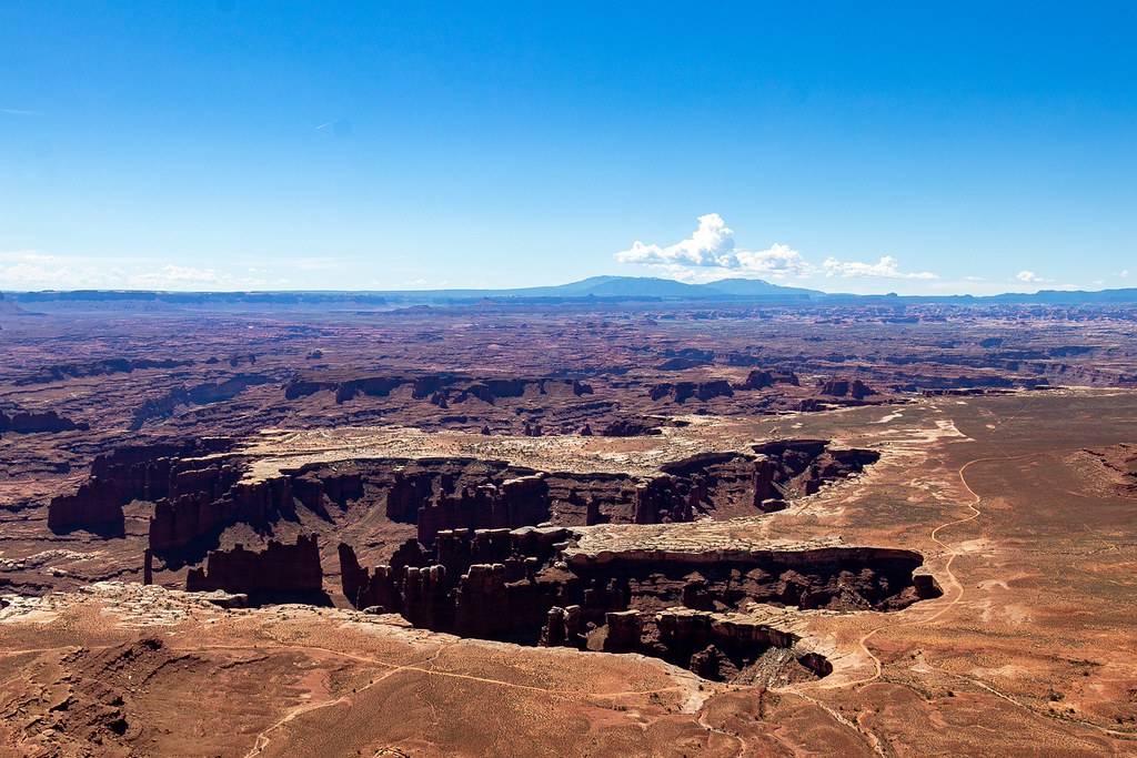
The Colorado and Green rivers have helped cut the canyon landscape. Our stops also included Mesa Arch (GCHQGR). Despite the name, that arch belongs to Canyonlands, a useful distinction when a vacation includes an entire neighboring park called Arches.
Mesa Verde: Following People Into the Cliffs
We crossed into Colorado for Mesa Verde on June 16. Here the sandstone held the work of people as well as the work of erosion. The cliff dwellings were built by Ancestral Pueblo people, with many dating to the 1200s. These were homes and communities, and seeing them in their setting made that history much more tangible.
Our visit included Balcony House Cliff Dwelling at Mesa Verde (GC31E22) and a ranger-guided tour. The photograph of the long ladder into Balcony House is a good reminder that this was an active visit. Apparently, after Angels Landing, we had not entirely finished climbing things.

The Balcony House route involves ladders, stone steps and a narrow tunnel. Moving through the site made its location in the cliff much more immediate than an overlook alone could have done. The history of the Ancestral Pueblo people also continues beyond these dwellings, through their descendants and the communities to which their ancestors moved.
Four States, Then the Lights of Las Vegas
The same day included Four Corners Monument, where Utah, Colorado, Arizona and New Mexico meet. The Navajo Nation operates the monument, and our family photograph records another stop together.
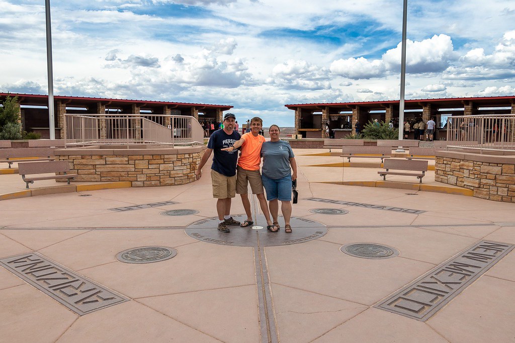
There were geocaching stops in all four states too, including Score 4 @ Four Corners - New Mexico (GC7B6JA). That is an unusually compact way to work a little geography into a vacation.
We finished the trip with time in Las Vegas. My finds there included Sign of Pawn Stars (GC5H20C), and the photographs changed from canyons and cliff dwellings to the sights of the city. After six national parks, it made quite a change of scene.
Looking back, the parks gave us an extraordinary variety of places to explore. Geocaching helped us look at some of them more closely, and photography gave us a way to bring pieces of the trip home. The best part is seeing all of that with bapierson and LEGOexplorer in the pictures.
And yes, I am keeping the one on the park sign.
Field Notes
- Adventure: June 2019
- Companions: bapierson and LEGOexplorer
- National parks: Zion, Bryce Canyon, Capitol Reef, Arches, Canyonlands and Mesa Verde
- Other stops: Four Corners Monument and Las Vegas
- Regular finds in the trip records: 84, including 27 EarthCaches and 16 Virtuals
- States with documented geocaching: Utah, Colorado, New Mexico, Arizona and Nevada
- Zion highlight: Angel’s Landing (GCG2ZP) with LEGOexplorer, June 11
- All photographs: Steven Pierson

No comments:
Post a Comment