Looking back on June 5–9, 2018
A family vacation in Arizona gives a geocacher a fairly convincing defense for stopping so often. The scenery is already on the itinerary. The EarthCaches and Virtuals just give us a few more things to notice while we’re there.
In June 2018, I traveled with bapierson and LEGOexplorer through a landscape that included the Grand Canyon, Meteor Crater, Petrified Forest, Horseshoe Bend, and Upper Antelope Canyon. Our wider vacation ran from June 5 through June 13, with time in Nevada and California as well. These Arizona days, June 5–9, had enough going on to fill a story of their own.
There were old highways, enormous views, a few actual cache containers, and an entirely unreasonable number of reasons to take another photograph. I was well equipped for that last part.
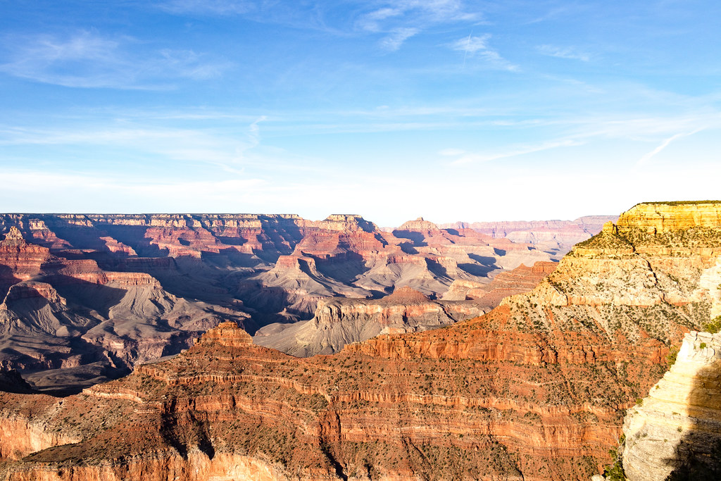
Below the Rim
The Grand Canyon occupied more than a quick stop on our route. We were there for the evening light on June 5, spent June 6 exploring, and photographed the canyon again early on June 7. Looking through those pictures, the changing light is almost another itinerary: warm cliffs in the evening, bright views during the day, and a very early start for sunrise.
Then we went below the rim on the Bright Angel Trail. The photos show the path working its way along the rock walls, and bapierson and LEGOexplorer together beneath an overhang. A canyon overlook gives you the big picture. Walking down into it puts those walls right beside you.
Our finds included Below the Rim (Don’t Follow the Raven) (GCG0HZ) and Grand Canyon Explorers (GCAF3E). These were Virtual Caches, so the experience centered on the place rather than a container tucked behind a rock. That suited this part of the vacation perfectly.

My logs from our Grand Canyon stops describe hiking, exploring, and beautiful sights. That is a fairly restrained summary of the landscape in the photographs. Apparently, even I sometimes run out of words before I run out of pictures.
By the evening of June 6, we were also exploring Williams, with its Route 66 signs and downtown stops. The canyon and the Mother Road were very different sides of Arizona, and having both in the same trip kept the miles between the big destinations interesting.
A Rather Sudden Change in the Landscape
On June 7, Meteor Crater supplied another enormous view, with a very different explanation. At the Grand Canyon, we had been looking at a landscape shaped over a long stretch of time. Here, the main event was an impact.
bapierson had been reluctant about stopping. She wasn’t sure why I wanted to go look at a big hole in the ground.
My reasoning was pretty simple: a big meteor crashed there. That seemed like a perfectly good reason to me.
An iron-nickel asteroid struck this part of Arizona about 50,000 years ago, leaving the crater we visited. NASA’s account of Meteor Crater makes the origin clear: this was an asteroid impact, not a volcano. Arizona was certainly keeping the geology portion of the vacation varied.
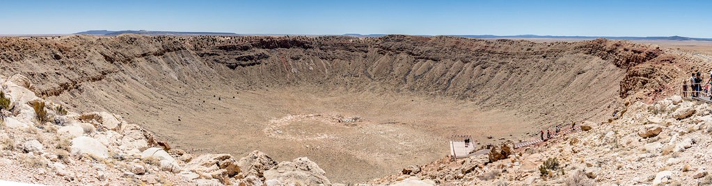
We logged both the Meteor Crater (GC6846) Virtual and Barringer Crater Earthcache (GCQJTA). An EarthCache makes you pay attention to the feature in front of you. With a crater this large, finding something worth looking at was not the difficult part.
Winslow was another June 7 stop, including Standin on the corner.... (GC64F7). That particular corner, its soundtrack, and my insistence on visiting belong in the companion story, Standin’ on a Corner in Winslow, Arizona. There was plenty more Arizona still ahead.
A Cache, an Old Road, and a Forest Made of Stone
Petrified Forest National Park spread our attention across two days, June 7 and 8. The name suggests a single attraction, but our photos and finds cover the Painted Desert, a historic inn, an old highway crossing, colorful badlands, and the petrified logs themselves.
At HistoricAZ66: Painted Desert Inn (GC3EPH7), we had a traditional cache to find inside the historic building. A photograph from this stop shows bapierson and LEGOexplorer holding the container. After the Grand Canyon and Meteor Crater Virtuals, here was the familiar satisfaction of having the actual thing in hand.

This was a ranger-placed cache associated with the Find Your Park GeoTour, a useful reminder that a national park cache can be part of an organized, authorized program. The inn itself has a longer story: an earlier stone building was transformed into the Pueblo Revival landmark now preserved as a museum. The National Park Service’s history of the building gives that stop another layer beyond the find.
Then HistoricAZ66: Petrified Forest – Route 66 (GC3EPG9) brought the highway connection out into the open landscape. There is a photograph of me beside the rusted car at the old crossing. It is quite a change from a busy modern road: an old vehicle, the trace of the highway, and a lot of Arizona around them.

On June 8, our finds included Blue Mesa – Desert Geomorphology (GCZ5H7) and two different caches called Crystal Forest: the Virtual (GCGTT4) and the EarthCache (GC50C8N). Same name, separate finds, and plenty to examine without searching for a hidden box.
Up close, the petrified wood still looks remarkably like wood—right up until the colors and stone surface remind you what you are actually seeing. Ancient buried logs were preserved through mineralization involving silica; the park’s explanation of petrified wood connects those patterns and colors to the minerals in the fossilized trees.

The close-up photographs earned their place alongside the wide views. A whole landscape can be impressive, but so can the end of a single log when it contains that much color and detail. It also made a good change of pace after several days of aiming the camera at things considerably larger than me.
One More Bend in the River
By the evening of June 8, we were at Horseshoe Bend near Page. The Colorado River curves around an enormous sandstone promontory below the overlook, making a scene that is recognizable even before you put a name to it.

Our Horseshoe Bend, Page Arizona (GC4VDY9) EarthCache find gave the visit a geocaching connection. The river and the evening view supplied the rest. Here in Glen Canyon National Recreation Area, we had another opportunity to see just how dramatically a river can shape the landscape.
Antelope Canyon
Upper Antelope Canyon, on June 9, was beautiful. That is still the first thing I think of when I look back at it.
The photographs show why: curved sandstone walls, warm orange and red surfaces, and shafts of light reaching down into the narrow space. After the huge, open views of the Grand Canyon and Horseshoe Bend, these pictures bring the landscape close again. The walls and light fill the frame.
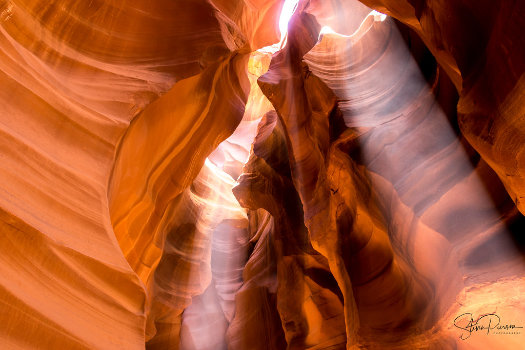
Upper Antelope Canyon is on the Navajo Nation, and visiting it is a guided experience. Its Navajo name, Tse’bighanilini, refers to the place where water runs through rocks. Standing among those walls gives that description something very tangible to go with it.
I called one of my photographs “Spotlights,” and the beams between those walls make the title fairly self-explanatory. The light was an attraction all by itself.
We also visited Glen Canyon Dam that day before continuing the wider trip. The Arizona portion had taken us from canyon overlooks to a trail below the rim, from an impact crater to an old highway, and from petrified trees to the light inside a slot canyon.
Geocaching ran through those days without needing to occupy every moment. Our visit to Antelope Canyon had nothing to do with geocaching and everything to do with the landscape and photography. At other stops, a cache gave us a particular feature to study or a container to find. Alongside all of that were bapierson, LEGOexplorer, and a camera full of places we had experienced together.
Field Notes
- Adventure: June 5–9, 2018, the Arizona portion of our June 5–13 family vacation
- Companions: bapierson and LEGOexplorer
- Places: Grand Canyon South Rim and Bright Angel Trail; Williams; Meteor Crater; Winslow; Petrified Forest and Painted Desert; Horseshoe Bend; Upper Antelope Canyon; Glen Canyon Dam
- Geocaching: Virtuals, EarthCaches and traditional caches; named finds are linked in the story
- Companion story: Standin’ on a Corner in Winslow, Arizona
- Photographs: Steven Pierson, June 2018

No comments:
Post a Comment