There are sensible ways to spend a weekend. Then there is leaving home on a Saturday evening, covering roughly 2,500 miles through twelve states, and coming back on Monday.
In October 2017, CanisMinor, mjholley, pandababy427 and I chose the second option. We called it the Midwest Rush Roadtrip, which is a fairly accurate name for an itinerary that needed only a little more than forty-eight hours to become a very ambitious loop on the map.

Six of those states would be new to my geocaching record. There were also two early caches I wanted to find, a Webcam, some history, a little geology and plenty of ordinary stops to break up the drive. It was going to take more than a quick run to the local forest preserve.
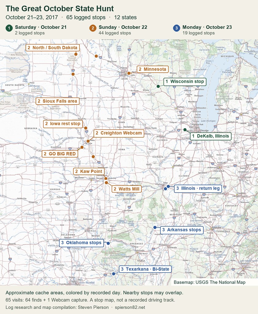
Explore all 65 stops by recorded day
1 Saturday, October 21 · 2 stops
| Cache | State | Recorded visit |
|---|---|---|
| Dekalb Oasis TB/Swag Hotel (GC4K4HK) | Illinois | Found it |
| Officers Scenic Cache (GCE67) | Wisconsin | Found it |
2 Sunday, October 22 · 44 stops
3 Monday, October 23 · 19 stops
| Cache | State | Recorded visit |
|---|---|---|
| Bi-State (GC829D) | Arkansas | Found it |
| Overlook Park CUS67 (GC145R3) | Arkansas | Found it |
| The 20th Century (GCBC27) | Arkansas | Found it |
| Visitor form outer space CUS67 (GCWV0Z) | Arkansas | Found it |
| Easy peezy lemon squeezy (GC3HFKW) | Illinois | Found it |
| You say Tomato, I say Toh-mah-toe (GC56AF6) | Illinois | Found it |
| Boulders for Timmy (GC224AG) | Oklahoma | Found it |
| Braden Mini Run #1 (GC4JG7Z) | Oklahoma | Found it |
| Braden Mini Run #2 (GC4JG85) | Oklahoma | Found it |
| Braden Mini Run #3 (GC4JG95) | Oklahoma | Found it |
| Braden Mini Run #4 (GC4JGA2) | Oklahoma | Found it |
| Colorful Corner (GC26DX9) | Oklahoma | Found it |
| Deserted Gas Well Pad (GC2JFAP) | Oklahoma | Found it |
| Dirt road quick pick (GC6XDCD) | Oklahoma | Found it |
| Tree or Pole? (GC2JFAR) | Oklahoma | Found it |
| Tristate ( 271/540) TB Hotel and Rest stop (GC1YHDW) | Oklahoma | Found it |
| Ace of Clubs House (GC2WQZA) | Texas | Found it |
| Museum of Regional History (GC2WR3C) | Texas | Found it |
| Serpent Park (GC285AA) | Texas | Found it |
Saturday evening, and a map with possibilities
We left the Plainfield–Joliet area around six on the evening of October 21 and returned at about six-thirty on Monday, October 23. A little more than forty-eight hours, with a lot of country to fit in between.
The northern leg took us through Wisconsin and Minnesota and into the Dakotas. BLT #796 (GC5JF9M) marked my first North Dakota find; nearby BLT #799 (GC5JF9R) did the same for South Dakota.
A pair of containers along a route might not sound like a major attraction. When you are adding two new states, they acquire a certain importance. I had been caching for years, but there was still plenty of blank space on my map.
We picked up more finds in South Dakota before continuing through Iowa toward Nebraska. The route was a mixture of quick stops and destinations worth spending more time with. That balance was what kept the trip interesting.
A Webcam, then an early Nebraska cache
In Omaha we visited Creighton Webcam (GCP9FF), on the university campus near the fountain in front of St. John’s Church. A Webcam find gives you a different kind of souvenir: a captured image proving you were there, rather than your name written in a container.
It made a nice change from the physical caches along the road. For this stop, being in the picture was the point of the find.
Then came GO BIG RED (GC943), hidden in Nebraska on May 10, 2001. This was one of the historic-cache destinations that gave our route more purpose than simply collecting state lines.
We took a photograph together with the ammo can. I like that picture because it includes both parts of the stop: the old cache we had come to find and the people who had made the journey with me.
Where the rivers meet
At Confluence at Kaw Point (GC232Y8), the Kansas River met the Missouri River, and our geocaching trip crossed into a different kind of history.
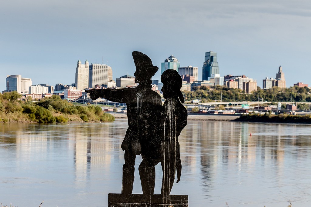
The Lewis and Clark expedition reached this confluence in June 1804. The modern park gave us river views, a sculpture of the explorers, and the Kansas City skyline beyond. The EarthCache focused attention on the meeting of the rivers themselves.
It was a good place to get out, look around and remember that we were traveling through places with stories much older than the hobby that had brought us there. Kansas was a new geocaching state for me; Kaw Point gave that addition a distinctive setting.
Missouri’s first, beside an older piece of history
Our other early-cache destination was Missouri’s First – Watts Mill (GC37), hidden June 20, 2000. Its original owner had read about GPS stash hunting, found no nearby cache to search for, and gone out in the rain to create one himself.
That is a wonderfully practical response to a shortage of geocaches.

The historic mill site beside Indian Creek added another layer to the visit. The mill had served the area long before anyone arrived with a GPS. Our photographs include the creek and an interpretive sign about the old millstones, as well as the find.
A short walk from parking brought us to a straightforward find, with the cache in good shape. We took another group photograph, this time gathered around the container in the woods.

Two caches from the hobby’s early years had given us reasons to stop in two different states. Both were much more satisfying than another anonymous point along the highway.
Down to Texas, with Arkansas on the other side
Our route continued through Oklahoma, where Braden Mini Run #4 (GC4JGA2) opened my find history in that state. By Monday we had reached Texarkana. Serpent Park (GC285AA) became my first Texas find.
Bi-State (GC829D) was a particularly appropriate Virtual for this trip. The Texas–Arkansas boundary runs through the post office and courthouse site. After spending so much of the weekend crossing state lines, we had reached one you could actually photograph beneath a sign.
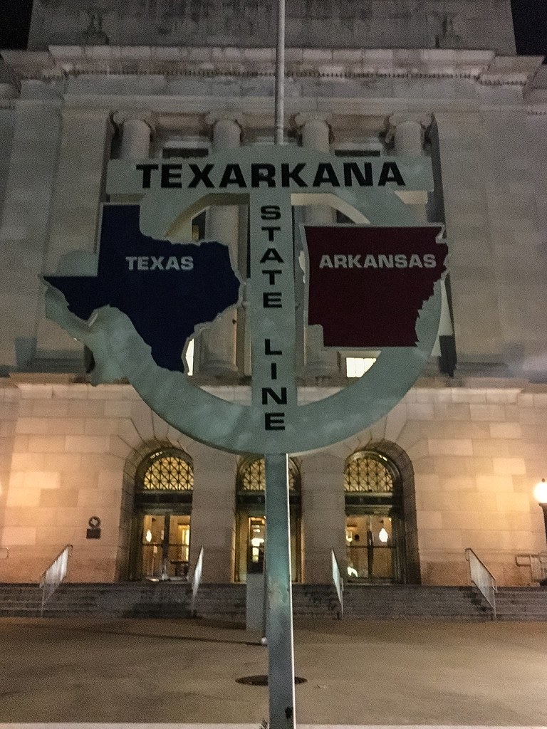
There were more Arkansas stops on the way home, then Illinois and the end of our loop. We had covered twelve states: Illinois, Wisconsin, Minnesota, North Dakota, South Dakota, Iowa, Nebraska, Kansas, Missouri, Oklahoma, Texas and Arkansas.
What the map doesn’t show
I came home with 65 credited cache visits from the trip: 64 finds and the Creighton Webcam capture.
The six new states were North Dakota, South Dakota, Nebraska, Kansas, Oklahoma and Texas. That was a very productive weekend for my map.
But the pictures I keep coming back to are the group shots at the old caches, the rivers at Kaw Point, and the state-line sign in Texarkana. They give the route faces and places instead of just a colored outline.
We had managed about 2,500 miles, twelve states and a little more than forty-eight hours together. The name Midwest Rush Roadtrip had been well earned. So had the photographs we brought home.
Field Notes
- Adventure
- October 21–23, 2017 — Saturday evening to Monday evening
- Companions
- CanisMinor, mjholley and pandababy427; logs signed individually or as Team MWRR
- Distance and duration
- Approximately 2,500 miles / a little over 48 hours, from original own and companion logs
- States visited
- Arkansas, Illinois, Iowa, Kansas, Minnesota, Missouri, Nebraska, North Dakota, Oklahoma, South Dakota, Texas, Wisconsin
- New geocaching states
- North Dakota, South Dakota, Nebraska, Kansas, Oklahoma and Texas
- Positive source records
- 65 credited visits: 64 finds and one Webcam capture; the export does not cover all unsuccessful searches
- Historic stops
- GO BIG RED (GC943) — May 10, 2001; Missouri’s First – Watts Mill (GC37) — June 20, 2000
- Other highlights
- Creighton Webcam (GCP9FF) · Confluence at Kaw Point (GC232Y8) · Bi-State (GC829D)

No comments:
Post a Comment